holoscience.com | The ELECTRIC UNIVERSE®
A sound cosmology for the 21st century
MARS and the GRAND CANYON
“The ultimate objective of comparative planetology, it might be said, is something like a vast computer program into which we insert a few input parameters (perhaps the initial mass, composition and angular momentum of a protoplanet and the population of neighboring objects that strike it) and then derive the complete evolution of the planet.”
Carl Sagan, The Solar System, Scientific American, September 1975, p.29.
First Law of Computing: Garbage in = garbage out.
Most people would think that experts agree on an explanation for the formation of such a grandiose site as the Grand Canyon. Surprisingly that isn’t so. It is an enigma. The latest attempt to figure it out occurred as late as June last year at the Grand Canyon Symposium 2000. The Colorado River is held generally responsible for carving the Canyon. However, even before the Glen Canyon dam stemmed its awesome desert floods, the river seems hopelessly inadequate to have formed such a geological spectacle. The Colorado River flows west from the Rockies and encounters a raised plateau known as the Kaibab Upwarp. Instead of turning away from that barrier it continues through the plateau. How could it do that? The river is much younger than the Kaibab Upwarp so it could not have progressively cut the Canyon even if the land rose very slowly. In any case, most of the material that was removed from the Canyon seems to be missing, according to a report from the symposium, leaving little evidential support for the original theory that a simple progression of water erosion formed the Canyon we see today. Since the 1930’s and 1940’s, geologists have searched for other explanations — that the Canyon once drained to the south-east (reversing the route of the present-day Little Colorado, then joining the Rio Grande and into the Gulf of Mexico. When problems arose with that explanation too, it was proposed that it once flowed NE along one of the present-day side tributaries such as Cataract Creek.

See: http://www.kaibab.org/geology/gc_geol.htm#how and The New York Times, June 6 2000, Making Sense of Grand Canyon’s Puzzles by Sandra Blakeslee]
Now let us consider a 21st century solution to the question of how the Grand Canyon was formed, based not only on Earthly evidence, but also on data returned by space probes and produced by more than a century of experimental and theoretical work in plasma laboratories.
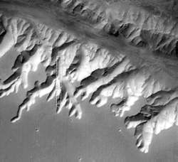
The Grand Canyon has often been compared in form, if not size, to the gigantic canyons of Valles Marineris on Mars. Because of these similarities it was initially thought that Valles Marineris was caused by massive water erosion at some earlier, supposedly wetter, epoch in Martian history. That idea has been abandoned because the evidence for water erosion and ponding in Valles Marineris is missing. The favored explanation now is that the surface of Mars has opened up with a giant tectonic rift, rather like the East African rift valley. Rifting is usually accompanied by vulcanism caused by increased heat flow from the interior. Yet major volcanic features are lacking in Valles Marineris. There are also many deep yet short tributary canyons, which require a different explanation. The favored one is undercutting by groundwater erosion. Both on Earth and Mars the canyons seem to have been cut cleanly into a raised flat surface. There is very little collateral damage to that surface. Is it likely that two different causes could end up creating landforms on two planets that look so similar?

Both vast canyons confront us with enigmas. Is there a simple answer?
At the heart of geology and planetary studies is a reasoning process called abduction. It is a form of logic whose major premise is certain and minor premise is probable. Then let us consider the question of flowing-liquid erosion. The major premise is “all sinuous channels are formed by a flowing liquid” and the minor premise is “Nirgal Vallis on Mars is a sinuous channel.” The deduction follows that “Nirgal Vallis was formed by a flowing liquid.”
 However such reasoning can be hopelessly misleading if the major premise is not certain. Mars is a desert planet with no possibility of flowing liquids today nor, it seems, for a long time past. But the huge channels look as if they were carved yesterday. That should be sufficient to doubt the major premise. However lazy logic forces us simply to conclude that there must have been large quantities of liquid water on Mars in the past. That is the present consensus. So typically the missing water has been conveniently consigned out of sight, beneath the Martian surface. The same thing was said of the channels on the Moon before the Apollo missions proved otherwise. Once again this incurious approach has led to huge expenditure on new spacecraft to detect sub-surface ice on Mars.
What if the major premise is completely wrong? What if none of the sinuous channels (usually called ‘rilles’) on Mars, Venus and our Moon, were originally formed by flowing liquids? This is a key question to be answered before we can address the more complex canyons on Mars and here on Earth. Rilles have the same form on all of these bodies, yet no one today seriously suggests that we look for water on the furnace-hot surface of Venus or on the airless Moon. Instead, hot fluid lava has been called upon as the flowing liquid on these bodies. The problem is that the lava had to remain liquid over hundreds, and in some cases thousands, of miles. So a roof of rock was added, to form lava tubes. But some of those roofs needed to be miles wide! Some rilles on the Moon and Venus are wider than the longest lava tubes on Earth. And the rock roofs had to collapse later to expose the channels. There is no rubble from collapsed roofs in any of the rilles. The rilles are cleanly chiselled into the surface. The lava is supposed to have flowed billions of years ago on the Moon, and only millions of years ago on Venus.
A good example of a lunar rille, photographed in great detail by the Apollo astronauts, is Schröter’s Valley. The channel looks brand new. Once again, the liquid that is supposed to have cut the channel is missing – there is no lava outflow. And lava cannot seep into the ground and be hidden as water can. Something is wrong with this picture. The major premise must be wrong.

There are many more mysterious features of these channels. Their wider “outflow” end is higher than the narrow “source” end, as if whatever formed them was not responding to gravity. In flagrant breach of that law, some run both uphill and down with no sign of the damage that might be expected if the topographical changes were due to later vertical movement of the terrain. Others cut through mountain ridges as if they were not an obstacle. Unlike rivers, rilles often run in parallel. Some have circular craters along their length, others seem to be formed from a continuous series of pits. Most terminate on a crater. Because of the many craters found in and around them, dating the rilles by crater counting makes them appear older than the surface they cut into. The channels are often much more sinuous for their width or the slope of the surface, than would be expected if they had been carved by a liquid. Some have a smaller, more sinuous channel in the floor of the larger channel. Some have flat floors and steep walls. Others have a deep V-shaped cross-section. Tributaries, if any, are often short, end in a circular alcove, and join the main channel at near right angles. To explain these (on worlds with water), recourse is usually made to underground water flows that remove soil and cause collapse and progressive headward erosion of the channel. Many channel floors show transverse markings or small ridges. On Mars they have been described as sand dunes. Many channels have material heaped up on each side to form levees. There are neither catchment areas nor systems of feeder streams sufficient to carve the often-gigantic main channels or tributary streams. The source and sink of the water remains invisible. And the question remains: where did the eroded soil go?
“The real actors on the stage of the universe are very few, if their adventures are many. The most ‘ancient treasure’ -in Aristotle’s words- that was left to us by our predecessors of the High and Far-off Times was the idea that the gods are really stars, and that there are no others. The forces reside in the starry heavens, and all the stories, characters and adventures narrated by mythology concentrate on the active powers among the stars, who are planets.” Giorgio Di Santillana and Hertha von Dechend in Hamlet’s Mill.
“The thundergod is regarded as the most powerful of all the gods of heaven and earth, since the effects of his anger are so terrible and so evident.” Christopher Blinkenberg in The Thunderweapon in Religion and Folklore.
See http://www.users.qwest.net/~mcochrane/Thundergods/thundergods.html
The answer has been available for 30 years! It was provided by an engineer, the late Ralph Juergens, of Flagstaff, Arizona. In a brilliant series of papers that would not be published in a mainstream scientific journal, he showed that flowing liquids are not adequate or even necessary to explain river-like channels on planets and their moons. He showed how the strange features of those channels could be simply scaled down and matched against the kind of damage caused by powerful lightning strikes on Earth. So even if Mars had surface moisture in the past its vast channels were not carved by rushing water.
 < Example of a powerful lightning strike at Baker, Florida in 1949. It furrowed the infield for 40 feet during a baseball game, killing 3 players and injuring 50 others. The more sinuous path taken by the lightning can be seen as a smaller trench in the bottom of the furrow. National Geographic, June 1950, p.827
When we look at the pattern of a lightning scar on Earth we see the features of sinuous rilles in miniature. Electrical phenomena exhibit the same forms from the scale of centimeters to the scale of thousands of kilometers. In fact, it has been shown in high-energy electrical experiments that the same patterns of behavior can be scaled up yet another 100 million times. Because of this, the forms of scars on insulators and semiconductors and/or the surface erosion of spark-machined objects, seen under a microscope, can be used as analogs of electrical scarring of planetary surfaces. Plasma cosmology can do inexpensive controlled experiments on Earth to answer puzzles that have plagued planetologists for decades.

Without a shadow of a doubt, Valles Marineris is an electrical arc scar. It bears the hallmarks, writ large on a planet’s face. Juergens identified it as such 30 years ago from the early Viking Orbiter spacecraft images.
“… to me this entire region resembles nothing so much as an area sapped by a powerful electric arc advancing unsteadily across the surface, occasionally splitting in two, and now and then-weakening, so that its traces narrow and even degrade into lines of disconnected craters. …I can only wonder: Is it possible that Mars was bled of several million cubic kilometers of soil and rock in a single encounter with another planetary body? Might the Canyonlands of Mars have been created in an event perhaps hinted at by Homer when he wrote: “Athena [Venus) drove the spear straight into his [Ares’ (Mars’)] belly where the kilt was girded: the point ran in and tore the flesh… [and] Ares roared like a trumpet…”
Juergens’ explanation requires a dynamic recent history of the solar system, entirely different from the one we have been taught to believe. It highlights an electrical dimension to astrophysics which is nowhere to be found in their textbooks. So it is little wonder that geologists are clueless when confronted with electrical erosion. When planets come close, gargantuan interplanetary lightning results. It is perfectly capable of stripping rock and gases from a planet against the puny force of gravity. It does so leaving characteristic scars. It can explain why some two million cubic kilometers of material is missing from Valles Marineris along with 90% of the atmosphere Mars was expected to have. A subsurface arc through an electrically coherent stratum can explain the peculiar morphology of Valles Marineris. The parallelism of the canyons is due to the long-range magnetic attraction of current filaments and their short-range strong electrostatic repulsion. Particularly significant are the small parallel rilles composed essentially of chains of craters. A traveling underground explosion follows the lightning streamer and cleanly forms the V-shaped tributary canyons. There is no collapse debris associated with undercutting water flow. Similarly, the “V” cross-section is usual for craters formed by underground nuclear explosions. The circular ends of the tributaries, where the explosion began, are precisely of that shape. In comparison, headward erosion by ground water sapping gives a U-shaped cross-section and does not necessarily end in a circular alcove. Note that some of the tributary canyons on the south rim of Valles Marineris cut across one another at near right angles. This might be due to repeated discharges from the same area chasing the main stroke as it travelled along Ius Chasma. No form of water erosion can produce crosscutting channels like that. The fluted appearance of the main canyon walls is probably due to the same travelling explosive action.

The walls of Valles Marineris shows evidence of widespread sedimentary layering on Mars. But such enormous quantities of sediment must have eroded from somewhere and the fact that any ancient highlands are preserved on Mars is difficult to reconcile with such a source. A second major difficulty is that Valles Marineris is near the top of a bulge 10 km above datum. How are sediments deposited at that altitude? It would require the region first being a deep basin to collect a thick stack of sediments (assuming there was copious fast-running surface water), then uplifted an incredible 20 km by a mantle plume and voluminous lava intrusions with little surface volcanism.
How many major premises in geology are wrong? The electrical model provides a far simpler solution never considered before in sedimentation. The material removed electrically from one body in a cosmic discharge is transferred in large part to the other body. That creates widespread surface layering. The airless Moon shows evidence too of extensive layering and it is covered in electrical scars.
The arguments for the electrical sculpting of Valles Marineris apply equally to the Grand Canyon. These major features on two very different planets look so similar for the simple reason that the same forces created them. Water was not involved in the process. Let us note the similarities. The Grand Canyon is on a high plateau. The tributaries are deeply incised, short, and tend to end in rounded alcoves. The tributary canyons of Ius Chasma are strikingly similar to those of the Grand Canyon. The material excavated from the Grand Canyon seems to be missing. On a watery Earth, the Colorado river simply took advantage of the sinuous channel carved by the subsurface cosmic lightning. The edges of the Grand Canyon are sharp and do not show much erosion into the mile deep valleys. That argues for very recent formation. Geologists cannot decipher the history of the Grand Canyon because their training never envisaged electrical erosion as a result of interplanetary thunderbolts. Nor did it teach that thick strata and anomalous deposits can be dumped from space in hours. Interplanetary electrical forces can raise mountains, twist and overturn strata, dump oceans on to land, preserve shattered flora and fauna in the rocks – all in a geological instant. But since Lyell, geologists have managed to lull us all into insensibility with vast time spans and piecemeal explanations for each morphological feature of the landscape. The question that should be asked is whether the slow causes they invoke are sufficient to the task they are asked to perform. Fossils do not form under normal circumstances. The sharp outlines of mountains and the tortured strata within them look like still frames from a dramatic action movie. And when it comes to assigning ages, cosmic thunderbolts cause radioactivity, change radioactive decay rates, and add and subtract radioactive elements. So the the assumptions underpinning the rickety edifice of geological dating will need re-examination without prejudice. Geologists are between a rock and a hard place because the main claim of geology to being a “hard” science has come from its bold claims to chart the history of the Earth. But it is clear that the chart they have been handed by cosmogonists and the clock bequeathed by the physicists are equally worthless.
 It is interesting to find that NASA and the SETI Institute have set up a base camp on Devon Island, Nunavut Territory, in the Canadian high arctic, for the scientific study of the Haughton impact crater and its surroundings. The joint study is known as the Haughton Mars project because the unexplored island is considered a Mars analog. Mars analogs are sites on the Earth where geologic features approximate those encountered on Mars. Devon Island has channels described as glacial meltwater networks. Several types of valleys resemble those seen on Mars. The resemblance appears to be more than superficial, as the similarities are often specific and unique. They have been compared to the tributary canyons of Valles Marineris and are claimed as perhaps the clearest evidence for episodes of sustained fluid erosion on Mars by water. However they present many unusual characteristics that cannot be explained by water erosion:
- the valleys are spaced apart with large undissected areas between valleys,
- the valleys display open, branching patterns with large undissected areas between branches,
- branches often have ill-defined sources but mature in width and depth over short distances relative to the size of the network,
- branches maintain relatively constant width and depth over long distances,
- branches split and rejoin to form steep-walled islands,
- branches have V-shaped cross-sections which transition to larger U-shaped troughs with steep walls and flat floors,
- channels on valley floors are absent or poorly expressed. Their scale also varies over an order of magnitude.

 < Aerial photograph of a 1 km-wide, deeply-incised, winding, V-shaped glacial trough valley on Devon Island with its tributaries. Note that the surrounding plateau is otherwise little dissected and that there are no major streams feeding onto this canyon. (Photo: NASA HMP)
V-shaped Devon Island valley. >
Here we have a different explanation from geologists for essentially the same morphological feature. The Devon valley networks are merely interpreted to be glacial meltwater channel networks formerly lying under an ice sheet. Some valleys do have a little ice in them today. However, the arguments for their formation by the action of ice make little sense. It suggests that glacial melting on a cold desert planet formed some Martian valley networks, which is hardly helpful. The strong similarities between the Devon valley networks and the tributaries of Valles Marineris, like that of the Grand Canyon to Valles Marineris, is simply because they were formed by the same process – a cosmic electric discharge. All of the unusual features listed above are expected in cathode erosion.
Even the nearby Haughton crater is to be expected, for the same reason that rilles on other planets and moons are associated with craters and often have more craters than the surrounding landscape. The Haughton crater is simply the scar of a cosmic thunderbolt, like practically every other circular crater in the solar system. So NASA is correct in their choice of analog, but wrong in their attribution of causes. In light of more than a century’s research in the field of plasma cosmology and the 20th century discoveries of the space age, we can confidently propose the celestial thunderbolt as a common cause of the formation of canyons and rilles on rocky planets and moons.
See: http://www.arctic-mars.org/docs/03c.LPSC.pdf
There is a geological perspective on planetary scars available at: http://disc.sci.gsfc.nasa.gov/geomorphology/GEO_10 where the difficulties facing geologists are often expressed. With the perspective offered here you may begin to form your own opinion.